
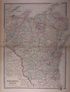
Dated 1889 Railroad & County Map of WISCONSIN by Wm. Bradley ~ (18x24)-#07
US $31.96US $31.96
Sun, Jun 29, 09:38 AMSun, Jun 29, 09:38 AM
Picture 1 of 2

Gallery
Picture 1 of 2


Have one to sell?
Dated 1889 Railroad & County Map of WISCONSIN by Wm. Bradley ~ (18x24)-#07
US $31.96
or Best Offer
Was US $34.00 (6% off)
Condition:
“This map is not *new* or in *new* condition, The map was removed from an antique 1889 Bradley Atlas. ”... Read moreabout condition
Ended: Jun 29, 2025 09:38:25 PDT
Oops! Looks like we're having trouble connecting to our server.
Refresh your browser window to try again.
Shipping:
Free USPS Ground Advantage®.
Located in: New Braunfels, Texas, United States
Delivery:
Estimated between Fri, Jul 25 and Thu, Jul 31 to 94104
Returns:
30 days returns. Seller pays for return shipping.
Payments:
Special financing available. See terms and apply now- for PayPal Credit, opens in a new window or tab
Earn up to 5x points when you use your eBay Mastercard®. Learn moreabout earning points with eBay Mastercard
Shop with confidence
Seller assumes all responsibility for this listing.
eBay item number:405707305450
Item specifics
- Seller Notes
- Date Range
- 1800-1899
- Format
- Atlas Map
- Title page
- The title page is not included in the sale.
- US State
- Wisconsin
- Year
- 1889
- S&H
- Free S&H USA - Calculated S&H Worldwide
- Original/Reproduction
- Antique Original
- Cartographer/Publisher
- Wm. M. Bradley
- Country/Region
- United States of America
Item description from the seller
Seller Feedback
No feedback yet
More to explore :
- Wisconsin 1930-1939 Date Range Antique North America County Maps,
- Wisconsin 1920-1929 Date Range Antique North America County Maps,
- Wisconsin 1900-1909 Date Range Antique North America County Maps,
- Wisconsin 1910-1919 Date Range Antique North America County Maps,
- Wisconsin 1800-1899 Date Range Antique North America County Maps,
- Wisconsin 1600-1699 Date Range Antique North America County Maps,
- Wisconsin County Map Antique North America Atlas Maps,
- Salem Wisconsin Antique North America County Maps,
- 1970-1979 Date Range Antique County Maps,
- 1910-1919 Date Range County Map Antique Folding Maps