
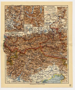
1939 VINTAGE MAP OF OSTMARK / WESTERN AUSTRIA TYROL / ITALY
US $29.99US $29.99
Sat, Apr 26, 11:31 AMSat, Apr 26, 11:31 AM
Picture 1 of 3


Gallery
Picture 1 of 3


Have one to sell?
1939 VINTAGE MAP OF OSTMARK / WESTERN AUSTRIA TYROL / ITALY
US $29.99
or Best Offer
Condition:
“SOME STAINS / SIZE: 9" x 7 1/2" (23 x 19 CM).”
Oops! Looks like we're having trouble connecting to our server.
Refresh your browser window to try again.
Shipping:
Free Standard Shipping from Canada.
International shipment of items may be subject to customs processing and additional charges.
Located in: Montreal, Quebec, Canada
Delivery:
Estimated between Tue, Jul 29 and Mon, Aug 4 to 94104
Returns:
60 days returns. Seller pays for return shipping.
Payments:
Special financing available. See terms and apply now- for PayPal Credit, opens in a new window or tab
Earn up to 5x points when you use your eBay Mastercard®. Learn moreabout earning points with eBay Mastercard
Shop with confidence
Seller assumes all responsibility for this listing.
eBay item number:405783643404
Item specifics
- Seller Notes
- “SOME STAINS / SIZE: 9" x 7 1/2" (23 x 19 CM).”
- Date Range
- 1930-1939
- Year
- 1939
- City
- Salzburg
- Country/Region
- Austria, Germany, Italy
Item description from the seller
Seller Feedback
No feedback yet
More to explore :
- Austria 1930-1939 Date Range Antique Europe Physical Maps,
- Austria 1930-1939 Date Range Antique Europe Sheet Maps,
- Antique European Maps & Atlases 1930-1939 Date Range Austria,
- Austria Vintage Original Antique Europe Maps & Atlases,
- Italy 1930-1939 Date Range Antique Europe City Maps,
- Italy 1930-1939 Date Range Antique Europe Physical Maps,
- Antique European Maps & Atlases Italy 1930-1939 Date Range,
- Austria Topographical Map Antique Europe Atlas Maps,
- Austria Antique Europe County Maps,
- Austria Lithography Antique Europe Sheet Maps