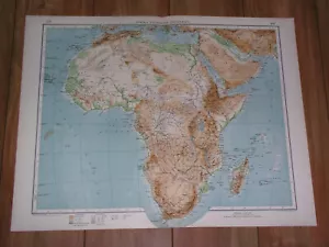


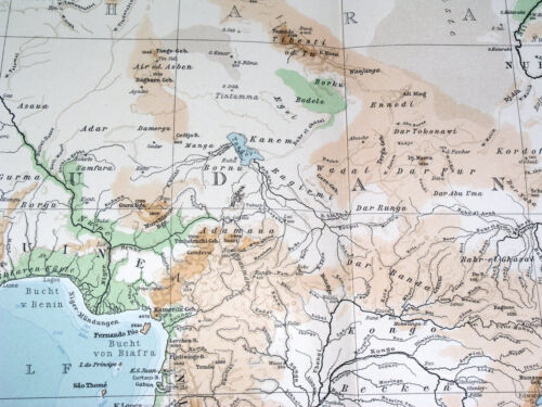


1911 ANTIQUE PHYSICAL MAP OF AFRICA / SAHARA KILIMANJARO MOUNTAINS RIVERS
US $27.53
or Best Offer
Condition:
“THE MAP IS REINFORCED ON BACK ALONG THE CENTERFOLD.”
Oops! Looks like we're having trouble connecting to our server.
Refresh your browser window to try again.
Shipping:
Free Standard Shipping from Canada.
International shipment of items may be subject to customs processing and additional charges.
Located in: Montreal, Quebec, Canada
Delivery:
Estimated between Fri, May 9 and Thu, May 15 to 43230
Please allow additional time if international delivery is subject to customs processing.
Returns:
60 days returns. Seller pays for return shipping.
Payments:
Special financing available. See terms and apply now- for PayPal Credit, opens in a new window or tab
Earn up to 5x points when you use your eBay Mastercard®. Learn moreabout earning points with eBay Mastercard
Shop with confidence
Seller assumes all responsibility for this listing.
eBay item number:405783649182
Item specifics
- Seller Notes
- “THE MAP IS REINFORCED ON BACK ALONG THE CENTERFOLD.”
- Date Range
- 1910-1919
- Type
- Physical Map
- Year
- 1911
- Country/Region
- Algeria, Benin, Burkina Faso, Cameroon, Cote d'Ivoire, Egypt, Equatorial Guinea, Ethiopia, Gabon, Gambia, Ghana, Kenya, Liberia, Libya, Mauritania, Morocco, Namibia, Nigeria, Senegal, Sierra Leone, South Africa, South Sudan, Togo, Uganda, Zaire
Item description from the seller
Seller Feedback
No feedback yet
More to explore :
- Antique Africa Physical Maps,
- Physical Map Antique Africa Atlas Maps,
- Antique Original Antique Africa Physical Maps,
- Antique Africa River Maps,
- Antique Physical Maps,
- Physical Map Antique Sheet Maps,
- Antique Europe Physical Maps,
- Physical Map Antique Folding Maps,
- Physical Map Antique Europe Atlas Maps,
- Antique Africa Maps & Atlases