
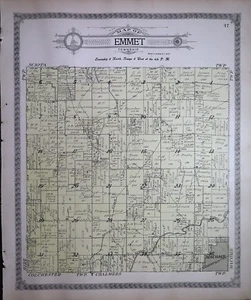
Old 1913 Plat Map of EMMET Twp., Mc DONOUGH Co., ILLINOIS - MACOMB ~Free S&H
US $28.00US $28.00
Fri, May 02, 02:34 PMFri, May 02, 02:34 PM
Picture 1 of 9


Gallery
Picture 1 of 9


Have one to sell?
Old 1913 Plat Map of EMMET Twp., Mc DONOUGH Co., ILLINOIS - MACOMB ~Free S&H

US $28.00
Ends in
Condition:
“Quick N Free S&H within USA. ~ Only reasonable offers considered. Browse through 1,000's of Rare, ”... Read moreabout condition
Ended: May 02, 2025 14:34:00 PDT
Oops! Looks like we're having trouble connecting to our server.
Refresh your browser window to try again.
Shipping:
Free USPS Ground Advantage®.
Located in: Schertz, Texas, United States
Delivery:
Estimated between Thu, Jul 31 and Wed, Aug 6 to 94104
Returns:
30 days returns. Seller pays for return shipping.
Payments:
Special financing available. See terms and apply now- for PayPal Credit, opens in a new window or tab
Earn up to 5x points when you use your eBay Mastercard®. Learn moreabout earning points with eBay Mastercard
Shop with confidence
Seller assumes all responsibility for this listing.
eBay item number:405790963654
Item specifics
- Seller Notes
- Frame
- Suitable for framing.
- US State
- Illinois
- Color
- Colored tints are original.
- Cartographer/Publisher
- Geo.A. Ogle & Co.
- California Prop 65 Warning
- None
- Date Range
- 1910-1919
- Type
- Plat/County Map
- Format
- Plat Atlas Map
- Year
- 1913
- Ref#
- #006
- Original/Reproduction
- Antique Original
- Country/Region
- United States of America
- Original
- This map page was printed in 1913.
Item description from the seller

Seller feedback (9,611)
- 1***l (18)- Feedback left by buyer.Past 6 monthsVerified purchaseFinally! The "ancestral plat map" arrived and is well worth the long wait!. It is as nice or even nicer than what the seller described. It was packaged adequately, I don't know why it took from 11 April to 5 May to be delivered, but I suspect this was outside the control/responsibility of the seller. I am grateful that this irreplaceable old document was not forever "lost in the mail." Thank you, thank you, thank you!1872 Plat Map ~ FENTON Twp., WHITESIDE Co., ILLINOIS - (15x18)-#10 (#405722860174)
- t***i (1205)- Feedback left by buyer.Past 6 monthsVerified purchasefast shipping...expertly packaged...received as shown/described...great communication...no issues...awesome seller!
- g***d (719)- Feedback left by buyer.Past monthVerified purchaseItem is as described, very well packaged, shipped & arrived promptly. Great seller, excellent communication a perfect transaction!! 👍👍
More to explore :
- Illinois Rand McNally & Co. Antique North America Maps & Atlases,
- Illinois County Map Antique North America Atlas Maps,
- Illinois County Map Antique North America Folding Maps,
- Illinois City Map Antique North America Atlas Maps,
- Illinois Railroad Map Antique North America Atlas Maps,
- Illinois Antique North America City Maps,
- Illinois Lithography Antique North America Atlas Maps,
- Illinois Contemporary Antique North America Maps & Atlases,
- Illinois Lithography Antique North America Geological Maps,
- Chicago Illinois Antique North America River Maps
Seller feedback (9,611)
- 1***l (18)- Feedback left by buyer.Past 6 monthsVerified purchaseFinally! The "ancestral plat map" arrived and is well worth the long wait!. It is as nice or even nicer than what the seller described. It was packaged adequately, I don't know why it took from 11 April to 5 May to be delivered, but I suspect this was outside the control/responsibility of the seller. I am grateful that this irreplaceable old document was not forever "lost in the mail." Thank you, thank you, thank you!1872 Plat Map ~ FENTON Twp., WHITESIDE Co., ILLINOIS - (15x18)-#10 (#405722860174)
- t***i (1205)- Feedback left by buyer.Past 6 monthsVerified purchasefast shipping...expertly packaged...received as shown/described...great communication...no issues...awesome seller!
- g***d (719)- Feedback left by buyer.Past monthVerified purchaseItem is as described, very well packaged, shipped & arrived promptly. Great seller, excellent communication a perfect transaction!! 👍👍