
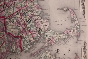
1863 Map ~ MASSACHUSETTS, CONNECTICUT, RHODE ISLAND by Johnson & Ward (18x26)#20
US $34.00US $34.00
Mon, Apr 28, 05:02 PMMon, Apr 28, 05:02 PM
Picture 1 of 3


Gallery
Picture 1 of 3


Have one to sell?
1863 Map ~ MASSACHUSETTS, CONNECTICUT, RHODE ISLAND by Johnson & Ward (18x26)#20
US $34.00
Ends in
Condition:
“This map was printed in 1863, it is not *new* or in *new* condition. It was removed from an Antique ”... Read moreabout condition
Ended: Apr 28, 2025 17:02:08 PDT
Oops! Looks like we're having trouble connecting to our server.
Refresh your browser window to try again.
Shipping:
Free USPS Ground Advantage®.
Located in: New Braunfels, Texas, United States
Delivery:
Estimated between Sat, Aug 2 and Fri, Aug 8 to 94104
Returns:
30 days returns. Seller pays for return shipping.
Payments:
Special financing available. See terms and apply now- for PayPal Credit, opens in a new window or tab
Earn up to 5x points when you use your eBay Mastercard®. Learn moreabout earning points with eBay Mastercard
Shop with confidence
Seller assumes all responsibility for this listing.
eBay item number:405803505599
Item specifics
- Seller Notes
- Format
- Atlas Map
- US State
- Connecticut, Massachusetts, Rhode Island
- Year
- 1863
- S&H
- Free S&H USA - Calculated S&H Worldwide
- Original/Reproduction
- Antique Original
- Cartographer/Publisher
- Johnson & Ward
Item description from the seller
Seller Feedback
No feedback yet
More to explore :
- Rhode Island County Map Antique North America Atlas Maps,
- Rhode Island Antique North America Railroad Maps,
- Rhode Island Antique North America County Maps,
- Rhode Island Antique North America Nautical Maps,
- Antique North American Maps & Atlases Rhode Island,
- Rhode Island Antique North America City Maps,
- Newport Rhode Island Antique North America Maps & Atlases,
- Boston Rhode Island Antique North America Maps & Atlases,
- Copper Plate Rhode Island Antique North America Atlas Maps,
- Providence Rhode Island Antique Original Antique North American Maps & Atlases