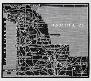


1836 Gordon Map Madison County NY Wampsville Canastota Cazenovia Chittenango

US $35.00
or 4 interest-free payments of $8.75 available with
Condition:
“See the pics and description below”
- Buy It Now1836 Gordon Map Madison County NY Wampsville Canastota Cazenovia Chittenango
Oops! Looks like we're having trouble connecting to our server.
Refresh your browser window to try again.
Shipping:
US $4.99 USPS Ground Advantage®.
Located in: Fairview, Pennsylvania, United States
Delivery:
Estimated between Wed, Jul 9 and Tue, Jul 15 to 94104
Returns:
30 days returns. Seller pays for return shipping.
Payments:
.
4 interest-free payments of $8.75 available with Klarna.
Special financing available. See terms and apply now- for PayPal Credit, opens in a new window or tab
Earn up to 5x points when you use your eBay Mastercard®. Learn moreabout earning points with eBay Mastercard
Shop with confidence
Seller assumes all responsibility for this listing.
eBay item number:405804182272
Item specifics
- Seller Notes
- “See the pics and description below”
- Date Range
- 1800-1899
- Type
- County Map
- Format
- Atlas Map
- US State
- DC, DE, MD, NJ, NY, PA, New York
- Printing Technique
- Woodcut
- Year
- 1836
- Cartographer/Publisher
- Thomas Gordon
- Original/Reproduction
- Antique Original
- City
- New York
- Country/Region
- United States of America
Item description from the seller

Popular categories from this store
Seller feedback (19,883)
- u***g (41)- Feedback left by buyer.Past 6 monthsVerified purchase--West Point WWII Map Operation in Italy Allied Advances from Jan 1944 to Jan 1945 (#365096664387)
- l***4 (122)- Feedback left by buyer.Past 6 monthsVerified purchase--
- x***u (151)- Feedback left by buyer.Past 6 monthsVerified purchase--
More to explore :
- Antique County Maps,
- County Map Antique Folding Maps,
- County Map Antique School Maps,
- County Map Antique Atlas Maps,
- County Map Antique Wall Maps,
- Lithography County Map Antique Sheet Maps,
- County Map Antique Asia Atlas Maps,
- County Map Antique Asia Sheet Maps,
- Antique Africa County Maps,
- Antique Original County Map Antique Sheet Maps
Popular categories from this store
Seller feedback (19,883)
- u***g (41)- Feedback left by buyer.Past 6 monthsVerified purchase--West Point WWII Map Operation in Italy Allied Advances from Jan 1944 to Jan 1945 (#365096664387)
- l***4 (122)- Feedback left by buyer.Past 6 monthsVerified purchase--
- x***u (151)- Feedback left by buyer.Past 6 monthsVerified purchase--