
1872 Map WASHINGTON TERRRITORY - INDIAN LANDS + OREGON by A. J. Johnson (13x18)
US $34.00US $34.00
Tue, Apr 29, 01:10 PMTue, Apr 29, 01:10 PM
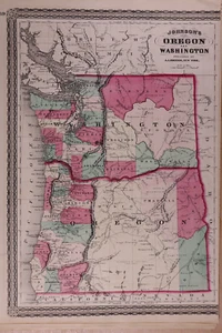

1872 Map WASHINGTON TERRRITORY - INDIAN LANDS + OREGON by A. J. Johnson (13x18)
US $34.00
Ends in
Condition:
“This map was printed in 1872, it is not *new* or in *new* condition. It was removed from an Antique ”... Read moreabout condition
Ended: Apr 29, 2025 13:10:06 PDT
Oops! Looks like we're having trouble connecting to our server.
Refresh your browser window to try again.
Shipping:
Free USPS Ground Advantage®.
Located in: New Braunfels, Texas, United States
Delivery:
Estimated between Fri, Jun 13 and Fri, Jun 20 to 94104
Returns:
30 days returns. Seller pays for return shipping.
Payments:
Special financing available. See terms and apply now- for PayPal Credit, opens in a new window or tab
Earn up to 5x points when you use your eBay Mastercard®. Learn moreabout earning points with eBay Mastercard
Shop with confidence
Seller assumes all responsibility for this listing.
eBay item number:405806386816
Item specifics
- Seller Notes
- Format
- Atlas Map
- US State
- Oregon, Washington
- Year
- 1872
- S&H
- Free S&H USA - Calculated S&H Worldwide
- Original/Reproduction
- Antique Original
- Cartographer/Publisher
- A. J. Johnson
Item description from the seller
Seller Feedback
No feedback yet
More to explore :
- Washington Oregon Antique North American Maps & Atlases,
- Washington Oregon Antique North America Topographical Maps,
- Washington Lithography Oregon Antique North America Maps & Atlases,
- Washington Oregon Antique Original Antique North American Maps & Atlases,
- Washington Oregon 1800-1899 Date Range Antique North America Maps & Atlases,
- Antique North American Maps & Atlases Oregon,
- Washington Washington Antique North America Sheet Maps,
- Oregon Antique North America Topographical Maps,
- Oregon Antique North America County Maps,
- Washington Topographical Map Antique North America Sheet Maps