
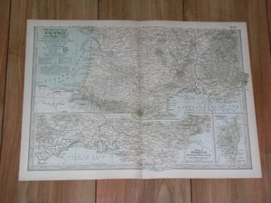
1897 ORIGINAL ANTIQUE MAP OF SOUTHERN FRANCE/ FRENCH RIVIERA INSET MAP
US $29.21US $29.21
Fri, May 09, 09:57 AMFri, May 09, 09:57 AM
Picture 1 of 11


Gallery
Picture 1 of 11


Have one to sell?
1897 ORIGINAL ANTIQUE MAP OF SOUTHERN FRANCE/ FRENCH RIVIERA INSET MAP
US $29.21
or Best Offer
Condition:
“GOOD / SOME STAINS.”
Oops! Looks like we're having trouble connecting to our server.
Refresh your browser window to try again.
Shipping:
Free Standard Shipping from Canada.
International shipment of items may be subject to customs processing and additional charges.
Located in: Montreal, Quebec, Canada
Delivery:
Estimated between Tue, Jul 22 and Mon, Jul 28 to 94104
Returns:
60 days returns. Seller pays for return shipping.
Payments:
Special financing available. See terms and apply now- for PayPal Credit, opens in a new window or tab
Earn up to 5x points when you use your eBay Mastercard®. Learn moreabout earning points with eBay Mastercard
Shop with confidence
Seller assumes all responsibility for this listing.
eBay item number:405812863570
Item specifics
- Seller Notes
- “GOOD / SOME STAINS.”
- Publication Year
- 1897
- Date Range
- 1800-1899
- Type
- Map
- Subgenre
- Italy
- Year
- 1897
- Region
- Italy
- City
- Marseille
- Country/Region
- France
- SHEET SIZE
- 6" x 11 1/2" (41 x 29 cm)
- Topic
- Antiques
- Maker
- THE CENTURY CO.
Item description from the seller
Seller Feedback
No feedback yet
More to explore :
- France Antique Original Antique Europe Political Maps,
- France Antique Original Antique Europe River Maps,
- France Antique Original Antique Europe County Maps,
- France Antique Original Antique Europe Folding Maps,
- France Antique Original Antique Europe Topographical Maps,
- France Topographical Map Antique Europe Atlas Maps,
- France County Map Antique Europe Atlas Maps,
- Antique Original City Map Antique Atlas Maps,
- Antique Original River Map Antique Folding Maps,
- Antique Original Nautical Map Antique Atlas Maps